利用网络泛地图资源评价15 min生活圈医疗服务可达性: 以上海市为例
网络健康咨询让医疗资源得以更广泛利用 #生活知识# #生活感悟# #科技生活变迁# #网络生活#
摘要: 现阶段中国投入大量资源用于基层医疗卫生服务能力建设,以15 min医疗圈为目标建设了卫生室、医保点等多种基层医疗保障设施,评价其可达性有助于设施的合理规划和优化调整。充分利用在线地图、人口热力图、路径规划服务、等时圈范围服务等泛地图资源,在基于胡弗模型的两步移动搜索法(Huff-based two-step floating catchment area method, Huff 2SFCA)的基础上,从出行能力差异、人口昼夜分布的角度进行改进,形成15 min核酸采样圈评价框架。以中国上海市为例分析15 min生活圈医疗设施可达性,结果显示: (1)研究区域内除宝山和浦东外的各行政区,15 min核酸采样圈的面积覆盖率和人口覆盖率均在90%以上,其中虹口、静安的可达性最高。(2)受通勤人群职住分离的影响,常住人口较多的地区在白天容易出现可达性过高的情况,且可达性在夜间降低,相反,产业聚集的地区夜间可达性明显升高。(3)外围的浦东、宝山等开发区呈现出可达性两极分化的特点,发展完善的居住板块可达性偏高,发展中的新产业园区可达性偏低;老城区的可达性分布相对更加均衡,且更能满足老年人群和职场人群的采样需求。分析结果反映出目前的采样点空间布局考虑了人群的出行行为,能满足大部分居民在居住地和工作地就近采样的需求。对于可达性过高和过低的区域,可根据人口分布的昼夜变化优化采样点资源配置。
Abstract:
Objectives At present, China has invested a large amount of resources in improving primary medical and health services. Aiming at 15 min medical circle, a variety of primary medical security facilities such as clinics and medical insurance stations have been built. Evaluation of their accessibility is of great significance for rational planning and optimization of facilities.
Methods We made full use of pan-map resources such as online map, population thermal map, path planning service and isochronous circle range service, and improved the Huff-based two-step floating catchment area method (Huff 2SFCA) from the perspective of travel capacity difference and day and night population distribution difference, and formed a 15 min nucleic acid sampling circle evaluation framework.
Results Taking Shanghai as an example to analyze the accessibility of medical facilities in 15 min living circle, the results show that: (1) In all administrative districts except Baoshan and Pudong in the study area, the area coverage and population coverage of the 15 min sampling circle are above 90%, among which Hongkou and Jing?an have the highest accessibility. (2) Affected by the separation between work and housing of commuters, the areas with large permanent residents tend to have high accessibility during the day, and the accessibility decreases at night. On the contrary, the areas with industrial clusters have significantly higher accessibility at night. (3) The surrounding development zones such as Pudong and Baoshan show the characteristics of polarization of accessibility. The accessibility of well-developed residential areas is high, while the accessibility of developing new industrial parks is low.The accessibility distribution of the old city is relatively more balanced, and can better meet the needs of the elderly and the working population.
Conclusions The results show that the current spatial layout of sampling stations considers the travel behavior of residents, and can meet the needs of most residents for testing near their residence and work place. For areas with high or low accessibility, the resource allocation of sampling points can be optimized according to the diurnal variation of population distribution.
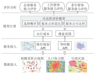
图 1 可达性评价框架
Figure 1. Accessibility Evaluation Framework
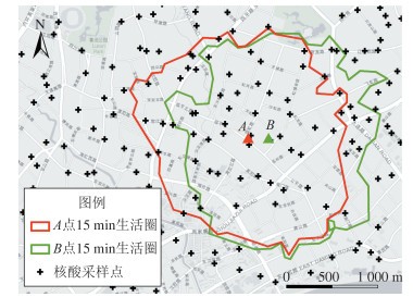
图 2 位于同一街区的A、B两点的等时圈范围
Figure 2. The Range of Isochronous Circle of Points A and B in the Same Block
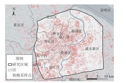
图 3 研究区域
Figure 3. Study Area
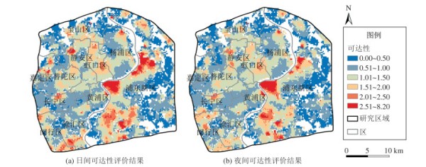
图 4 上海市中心城区15 min生活圈采样点可达性评价结果
Figure 4. Accessibility Evaluation Results of Sampling Points in the 15 min Living Circle in Downtown Shanghai
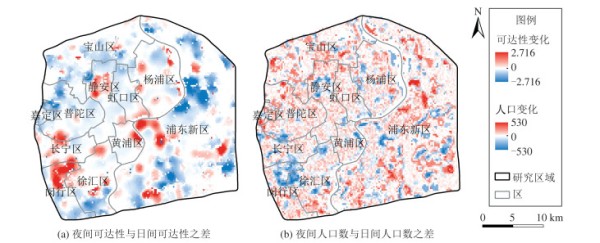
图 5 研究区域内日间至夜间可达性与人口数变化
Figure 5. Day-to-Night Accessibility and Population Changes in the Study Area
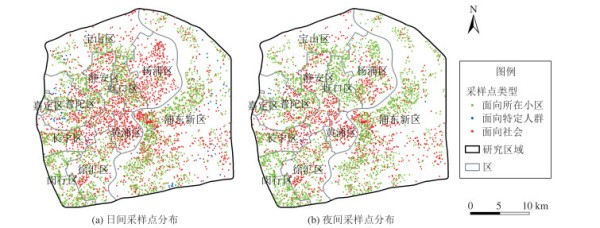
图 6 研究区域内日间与夜间采样点分布
Figure 6. Distribution of Sampling Points in Day and Night in the Study Area
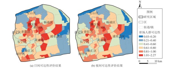
图 7 针对职场人群的可达性评价结果
Figure 7. Accessibility Evaluation Results for Workplace Groups
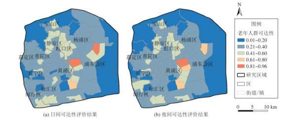
图 8 针对老年人群的可达性评价结果
Figure 8. Accessibility Evaluation Results for the Elderly Groups
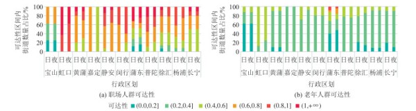
图 9 按区统计不同可达性等级的街道数量占比
Figure 9. Percentage of Streets with Different Accessibility Levels by District
表 1 按区统计可达区域的面积覆盖率和人口覆盖率/%
Table 1 Area Coverage and Population Coverage of Accessible Areas by District/%
区名 AAI > 0区域面积覆盖率 AAI > 0区域
人口覆盖率 AAI > 1区域
面积覆盖率 AAI > 1区域
人口覆盖率 黄浦区 98.20 98.84 48.87 46.24 徐汇区 92.38 93.77 43.17 44.87 长宁区 94.57 96.12 25.07 24.54 静安区 97.24 97.47 71.30 71.15 普陀区 90.81 93.94 51.95 54.19 虹口区 98.34 98.55 95.21 95.68 杨浦区 90.09 97.10 42.87 49.24 闵行区 92.63 93.60 62.61 61.63 宝山区 67.86 74.66 20.68 25.28 嘉定区 92.37 94.93 29.66 29.59 浦东新区 78.23 84.14 37.26 45.55 [1] 郭仁忠, 陈业滨, 赵志刚, 等. 泛地图学理论研究框架[J]. 测绘地理信息, 2021, 46(1): 9-15 https://www.cnki.com.cn/Article/CJFDTOTAL-CHXG202101004.htm
Guo Renzhong, Chen Yebin, Zhao Zhigang, et al. A Theoretical Framework for the Study of Pan-Maps[J]. Journal of Geomatics, 2021, 46(1): 9-15 https://www.cnki.com.cn/Article/CJFDTOTAL-CHXG202101004.htm
[2]Gartner G, Bennett D A, Morita T. Towards Ubiquitous Cartography[J]. Cartography and Geographic Information Science, 2007, 34(4): 247-257 doi: 10.1559/152304007782382963
[3]Peterson M P. Trends in Internet and Ubiquitous Cartography[J]. Cartographic Perspectives, 2008(61): 36-49 doi: 10.14714/CP61.213
[4] 郭仁忠, 陈业滨, 应申, 等. 三元空间下的泛地图可视化维度[J]. 武汉大学学报·信息科学版, 2018, 43(11): 1603-1610 doi: 10.13203/j.whugis20180373Guo Renzhong, Chen Yebin, Ying Shen, et al. Geographic Visualization of Pan-Map with the Context of Ternary Spaces[J]. Geomatics and Information Science of Wuhan University, 2018, 43(11): 1603-1610 doi: 10.13203/j.whugis20180373
[5] 郭仁忠, 陈业滨, 马丁, 等. 论ICT时代的泛地图表达[J]. 测绘学报, 2022, 51(7): 1108-1113 https://www.cnki.com.cn/Article/CJFDTOTAL-CHXB202207002.htmGuo Renzhong, Chen Yebin, Ma Ding, et al. Pan-Map Representation in ICT Era[J]. Acta Geodaetica et Cartographica Sinica, 2022, 51(7): 1108-1113 https://www.cnki.com.cn/Article/CJFDTOTAL-CHXB202207002.htm
[6] 王思, 王光霞, 田江鹏. 面向位置聚合的泛在地图信息分类模型[J]. 测绘学报, 2021, 50(6): 789-799 https://www.cnki.com.cn/Article/CJFDTOTAL-CHXB202106009.htmWang Si, Wang Guangxia, Tian Jiangpeng. Classification Model of Ubiquitous Map Information Facing Location-Based Aggregation[J]. Acta Geodaetica et Cartographica Sinica, 2021, 50(6): 789-799 https://www.cnki.com.cn/Article/CJFDTOTAL-CHXB202106009.htm
[7]Sharma G, Patil G R. Spatial and Social Inequities for Educational Services Accessibility: A Case Study for Schools in Greater Mumbai[J]. Cities, 2022, 122: 103543 doi: 10.1016/j.cities.2021.103543
[8]Wang S, Wang M, Liu Y. Access to Urban Parks: Comparing Spatial Accessibility Measures Using Three GIS-Based Approaches[J]. Computers, Environment and Urban Systems, 2021, 90: 101713 doi: 10.1016/j.compenvurbsys.2021.101713
[9] 卢永华, 李爽. 改进G2SFCA的深圳市室内应急避难场所空间可达性研究[J]. 武汉大学学报·信息科学版, 2019, 44(9): 1391-1398 doi: 10.13203/j.whugis20180456Lu Yonghua, Li Shuang. Spatial Accessibility of Indoor Emergency Shelters Based on Improved G2SFCA in Shenzhen City[J]. Geomatics and Information Science of Wuhan University, 2019, 44(9): 1391-1398 doi: 10.13203/j.whugis20180456
[10]Li M, Wang F, Kwan M P, et al. Equalizing the Spatial Accessibility of Emergency Medical Services in Shanghai: A Trade-Off Perspective[J]. Computers, Environment and Urban Systems, 2022, 92: 101745
[11] 郭琛琛, 梁娟珠. 基于网络地图的多交通模式医疗设施可达性分析[J]. 地球信息科学学报, 2022, 24(3): 483-494 https://www.cnki.com.cn/Article/CJFDTOTAL-DQXX202203006.htmGuo Chenchen, Liang Juanzhu. Accessibility Analysis of Medical Facilities Based on Multiple Transportation Modes of Network Map[J]. Journal of Geo-information Science, 2022, 24(3): 483-494 https://www.cnki.com.cn/Article/CJFDTOTAL-DQXX202203006.htm
[12] 仝德, 孙裔煜, 谢苗苗. 基于改进高斯两步移动搜索法的深圳市公园绿地可达性评价[J]. 地理科学进展, 2021, 40(7): 1113-1126 https://www.cnki.com.cn/Article/CJFDTOTAL-DLKJ202107004.htmTong De, Sun Yiyu, Xie Miaomiao. Evaluation of Green Space Accessibility Based on Improved Gaussian Two-Step Floating Catchment Area Method: A Case Study of Shenzhen City, China[J]. Progress in Geography, 2021, 40(7): 1113-1126 https://www.cnki.com.cn/Article/CJFDTOTAL-DLKJ202107004.htm
[13]Luo W, Wang F. Measures of Spatial Accessibility to Healthcare in a GIS Environment: Synthesis and a Case Study in Chicago Region[J]. Environment and Planning B, Planning and Design, 2003, 30(6): 865-884
[14] 陶卓霖, 程杨. 两步移动搜寻法及其扩展形式研究进展[J]. 地理科学进展, 2016, 35(5): 589-599 https://www.cnki.com.cn/Article/CJFDTOTAL-DLKJ201605006.htmTao Zhuolin, Cheng Yang. Research Progress of the Two-Step Floating Catchment Area Method and Extensions[J]. Progress in Geography, 2016, 35(5): 589-599 https://www.cnki.com.cn/Article/CJFDTOTAL-DLKJ201605006.htm
[15]Luo W, Qi Y. An Enhanced Two-Step Floating Catchment Area (E2SFCA) Method for Measuring Spatial Accessibility to Primary Care Physicians[J]. Health and Place, 2009, 15(4): 1100-1107
[16]Dai D. Racial/Ethnic and Socioeconomic Disparities in Urban Green Space Accessibility: Where to Intervene?[J]. Landscape and Urban Planning, 2011, 102(4): 234-244
[17]Luo W, Whippo T. Variable Catchment Sizes for the Two-Step Floating Catchment Area (2SFCA) Method[J]. Health and Place, 2012, 18(4): 789-795
[18]McGrail M R, Humphreys J S. Measuring Spatial Accessibility to Primary Health Care Services: Utilising Dynamic Catchment Sizes[J]. Applied Geography, 2014, 54: 182-188
[19] 陶卓霖, 程杨, 戴特奇. 北京市养老设施空间可达性评价[J]. 地理科学进展, 2014, 33(5): 616-624 https://www.cnki.com.cn/Article/CJFDTOTAL-DLKJ201405003.htmTao Zhuolin, Cheng Yang, Dai Teqi. Measuring Spatial Accessibility to Residential Care Facilities in Beijing[J]. Progress in Geography, 2014, 33(5): 616-624 https://www.cnki.com.cn/Article/CJFDTOTAL-DLKJ201405003.htm
[20]Dony C C, Delmelle E M, Delmelle E C. Re-conceptualizing Accessibility to Parks in Multi-modal Cities: A Variable-Width Floating Catchment Area (VFCA) Method[J]. Landscape and Urban Planning, 2015, 143: 90-99
[21]Delamater P L. Spatial Accessibility in Suboptimally Configured Health Care Systems: A Modified Two-Step Floating Catchment Area (M2SFCA) Metric[J]. Health and Place, 2013, 24: 30-43
[22]Wan N, Zou B, Sternberg T. A Three-Step Floating Catchment Area Method for Analyzing Spatial Access to Health Services[J]. International Journal of Geographical Information Science, 2012, 26(6): 1073-1089
[23]Luo J. Integrating the Huff Model and Floating Catchment Area Methods to Analyze Spatial Access to Healthcare Services[J]. Transactions in GIS, 2014, 18(3): 436-448
[24]Mao L, Nekorchuk D. Measuring Spatial Accessibility to Healthcare for Populations with Multiple Transportation Modes[J]. Health and Place, 2013, 24: 115-122
[25]Fransen K, Neutens T, de Maeyer P, et al. A Commuter-Based Two-Step Floating Catchment Area Method for Measuring Spatial Accessibility of Daycare Centers[J]. Health and Place, 2015, 32: 65-73
[26]Chen X, Jia P. A Comparative Analysis of Accessibility Measures by the Two-Step Floating Catchment Area (2SFCA) Method[J]. International Journal of Geographical Information Science, 2019, 33(9): 1739-1758
网址:利用网络泛地图资源评价15 min生活圈医疗服务可达性: 以上海市为例 https://www.yuejiaxmz.com/news/view/978809
相关内容
老年人 15 分钟社区生活圈:基于服务可达性和街道建筑环境的步行可达性澎湃问卷:上海15分钟社区生活圈市民满意度调查
2024年度上海15分钟社区生活圈优秀案例评选正式启动!
基于POI的十五分钟生活圈公共服务设施空间布局及可达性研究
上海为什么要加快15分钟生活圈建设?
基于供需匹配的15分钟社区生活圈分析与优化——以上海为例,PLOS ONE
如何理解数字经济在杭州市15分钟社区生活圈中的作用及其对外卖行业服务可达性的影响?
远程医疗服务网络覆盖所有市县
“15分钟医疗服务圈”来了!
我市以社区为单位打造15分钟生活圈 让市民尽享舒适便利生活
随便看看
最新动态分享
- 十种适合放在室内的绿色植物
- 居家绿色植物有哪些?
- 居家绿植养护:低成本装点家居,治愈现代人的精神内耗
- 这几种绿植最适合放在家里,既能为房间增色还很好养活
- 怎样才能不杀死你的植物 (四季居家绿植的家庭园艺指南)
- 一帆风顺植物的养殖秘籍(打造居家绿色健康生活)
- 适合北方室内养的开花植物?
- 室内居家环境生活绿植盆栽花卉素材图片免费下载
- 家庭常用绿色植物,家庭常用绿色植物知识
- 个人防蚊小贴士(链接)
热点动态分享
- 144968
- 51381
- 44945
- 42339
- 40738
- 30782
- 25449
- 25384
- 21773
- 18480